Continuing on then...

So, since the Ooh-Aah Pt. was so aptly named, I really had to wonder what was around the corner at this location!!

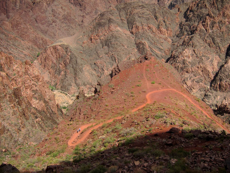
Looking down at the zigzags. You can see a couple of guys hiking their way up at one of the zags (or is it a zig?!). I'm really amazed at the folks who make it UP the South Kaibab! It was a relentlessly DOWN downhill for me, enough so that some of my leg muscles acted like they were thinking of cramping up at the end (although they never did, thank goodness!). I just can't imagine doing that much UP, UP, UP - and with a full backpack! They were just super lucky to have those clouds!! South Kaibab has virtually NO shady spots on it and NO water sources, unlike the Bright Angel, which has a fair amount of both.

Love "around the corner" shots...


A bigger view of the zigzags...

Look at all the shoring up with rocks trail workers have done.

Looking back and up near the start point - this is where the trail comes over and around that ridge.


Ah, the mules. These hard-working critters make the GC a more doable experience for so many of us - those who ride them but also those who enjoy all the luxuries the mules haul up and down every day! The mules and their drivers get a very early start - I ran into these guys on their way up at around 7am or so, and they were nearly halfway up already. Some people hiking in have the mules carry their heavier stuff down/up for them.

Billy and I are quite fond of mules. Poor guys - such hard work in this environment, and someone told me that while the mule trains have never lost a person, I guess they have lost some mules... :(

A line-up. Perfect spot for a photo-up on their way back up. Love the Pink Shirt Ladies. Is that like the Purple Hat Society?

Having just left the Tonto Plateau, and the Tipoff rest stop and restroom, the trail here is about to lead into the Inner Canyon. At the top/the rims, the canyon is very wide, but it's almost like there is a secondary canyon in the bottom half, and the walls are a lot more narrow for that part. In turn, things heat up quite a bit more down below. Not only are you about a mile lower in elevation at the bottom, but the sun bounces off all the canyon walls and makes things much more oven-like! So, instead of ~70 degrees at the top, plan on ~90 down below! Typically, 20 degrees higher! Yuck! So that's why everyone gets an early start, including the mules (I would think!)!

One of the first glimpses at the Colorado River! And see those two teeny figures on canyon wall left? Two more down & up day hikers!

And, of course, as with all other hikers that day, they passed me...

Another of the few, very pretty cacti on the way down preview the prolific cactus gardens to be found around Phantom Ranch.

The river, Bright Angel Creek, a mule corral and other older, now abandoned buildings, a helipad, and the trail snaking along the far canyon-side, leading towards the oasis of trees, towards Bright Angel Campground and Phantom Ranch.

The whole view showing the crevice that that oasis is in. Bright Angel Campground is on the left side of the trees. Phantom Ranch is on the back side/upstream of the little forest.

A happy moi!


Cute friend. See? I never really hike alone!

Some very cool agaves. If you look REAL close, you'll see the bee hovering over the blooms on the flower stalk!

More friends! But they weren't acting very friendly - at least not to each other! I interrupted their little war stand-off, probably to the littler guy's relief!
Yet another couple that passed me...

At this point, you can see almost all the rest of the trail going down to the river, as well as the "black bridge" (yes, it is black - at least partly - and it is the connector between the South and North Kaibab trails).

Here, you can see how the terrain/trail colors change! They go from red to pink to regular "dirt color."

Another river view.

Getting closer! Again, you can see the color shifts on the trail.

But my shoes didn't change color too much - they just retained that initial RED color! :)

The black bridge. Pretty cool, huh? Or should I say, it's HOT stuff?!

The Colorado River, with the "silver bridge" (connecting to the Bright Angel Trail, which I will take back up, like most folks) in the background.

Boat Beach. A great spot where rafters stop and hang out. I ran into some rafters who ended their river trip here, doing the other part of their trip with a stay at Phantom Ranch and a hike up.
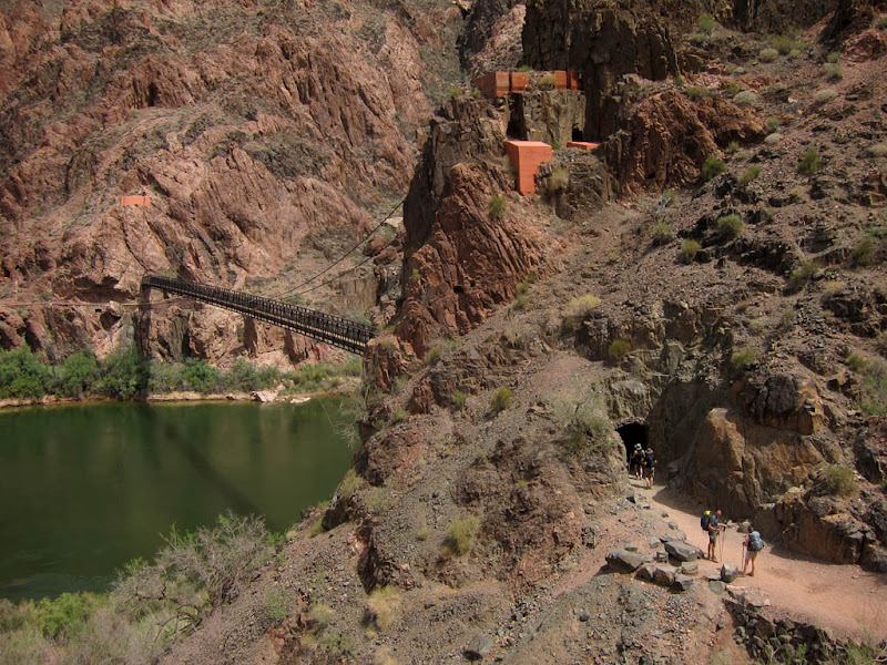
To access the black bridge from the South Kaibab Trail, you need to go through a tunnel. Here, you can see hikers entering it. Too cool! Too hot!!

The bridge.


The bridge becomes an overpass, as the trail winds down and under it.

Boat Beach again. In case you can't read it, the sign says you are at 2400ft elevation and that if you go swimming here or drink the water without treating it first, you are stupid. Well, not in those words exactly. But you will probably end up downstream/drowned/dead or sick, respectively.

More pretty cactus flowers.

Trail leading to the campground/Phantom Ranch. Let the cactus gardens begin!

This part almost felt like it took the longest (even though it wasn't!)! Now solidly in the 90+ degree zone and unsure how much farther I had yet to go, each step felt longer than it should be...! Between the trees you can see the little short bridge that connects the Kaibab and Bright Angel trails.
No comments:
Post a Comment